A few days ago I answered twenty questions about my new campaign setting, the Eleven Pillars (thanks to Blog of Holding for the inspiration). That post, found HERE, is still sitting in my mind, spawning ideas. I thought it would be a good idea to show you the map and discuss some things I am thinking about with respect to the placement of certain elements.
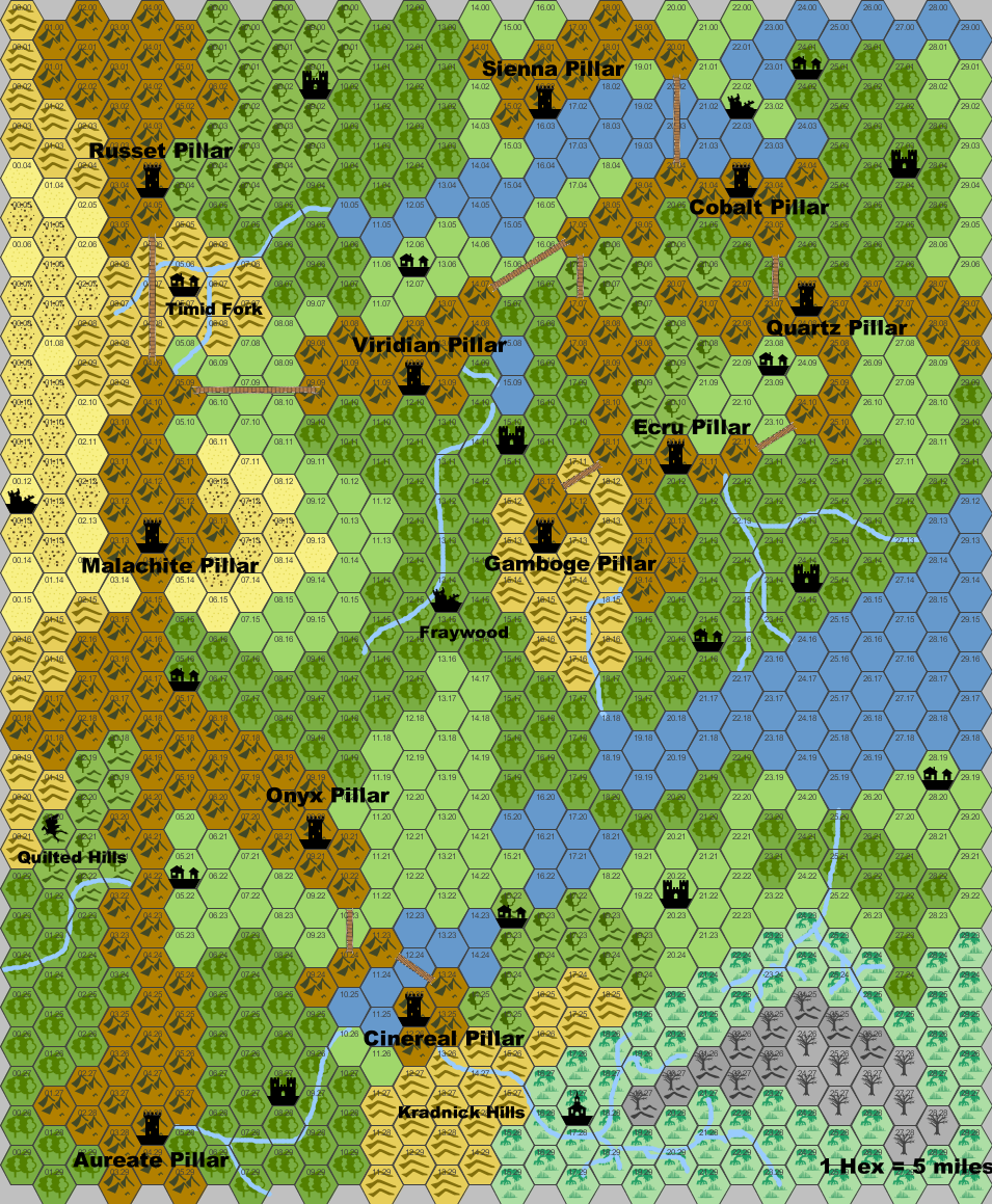
Here is the map so far:
Some notes about what you see on the map…
1) The Scale and Size: 1 hex = 5 miles; the map is 30×30 hexes, making the total area approximately 22,500 square miles.
2) Terrain: I tried to limit the types of terrain I placed on the map, and I ended up with mountains, forest, forested hills, hills, grassland/plains, swamp, dead forest, dead forested hills, lakes, desert, and rocky desert. Adding in the rivers and you can see 12 different types of terrain on the map. I tried to keep the forests, grasslands, and mountains most prominent and I tried to place the terrain in a way that made sense and didn’t appear random (though there are, obviously, choices I made that are completely arbitrary.
3) Structures: I added in icons for 11 pillars, 9 cities/villages, 6 castles, 1 temple, 3 ruins, and 1 dragon’s lair. Keep in mind that, other than the pillars which are known entities in the mountainlands, the map shows the assumed/rumored locations of the structures, and there is room for many many other items on the map. I envision it being open to traditional hex-crawl style exploration. This is to be a fantastical area for the PCs to discover as they go, and I tried to maintain that idea while still providing enough structures to make the map interesting.
4) Labels: I named each of the Eleven Pillars as well as the 4 areas that I discussed in my last post as regions of interest to the PCs (Timid Fork, Kradnick Hills, Quilted Hills, and Fraywood). I decided NOT to label other areas as I am undecided on the names and flavor of those areas and I want to keep things relatively flexible, at least at this stage.
5) Bridges: You will notice several thin brown lines connecting the mountain ranges on which the Pillars are placed – these are the ancient bridges. The ancient footbridges. Yes, footbridges. The current residents of the Pillars don’t know who built the bridges or how they are maintained. The longest of these bridges spans the 15 mile gap between the ranges housing the Malachite Pillar and the Russet Pillar.
I added bridges because I didn’t want to make airships a required part of the setting, though they are definitely still a possibility, they are not a necessity. There is also the option of having a large animal transport people from one range to the next, and that option is still under consideration, but will probably NOT replace the bridges. The other idea that opened up regarding the bridges was an off-hand comment I made about the bridge troll that might be living under one of the bridges. Imagine that – a bridge troll so high up in the air – remember that the Pillars are at the highest elevations (above the cloudline) – it must have some peculiar properties to be able to live under one of those bridges. So… it might have wings. Yes, a flying bridge troll – horrific, right? They may not be extremely common, but they do exist.
Okay – that’s all for right now. Ancient footbridges, named pillars, some basic terrain features, and several new types of creatures are all in place now. This setting is shaping up to be something interesting, flexible, and mysterious. I am trying to temper some of the more gonzo ideas I am having, while maintaining some innovative flavor. What’s next? I think I will write up small backgrounds for some of the Pillars as well as a few of the structures in the Lowerlands. I think a few rumor tables are in order as well. I am still noodling through the ideas regarding pirates, but haven’t settled on anything yet.
Until next time, I wish you good gaming!
~DM Samuel


3 thoughts on “Eleven Pillars Map and Notes”