The Darlene Map of Greyhawk
When we look at the beautiful 1980 map of Greyhawk1 (lovingly referred to as The Darlene Map) we see that the Prelacy of Almor looks a barren, less-traveled place in 576 CY. This couldn’t be further from the truth, however, as there are (should be) small towns and villages sprinkled throughout the land, but the 30 miles per hex scale of Darlene’s map makes adding every thorp, village, and town unwise. Almor is, after all, a land of farmers, herders, fishers, foresters, and miners2, and most of the land should be given up to those activities, but there must be small thorps and hamlets between swaths of farmland and herding pastures. Given rates of travel in AD&D, a person afoot or a horse with wagon can travel roughly 30 miles per day3. One would think that thorps, villages or small waypoints would be no farther than a day or two travel away4,5. The wilderness between towns is dangerous and most traveling merchants or townsfolk would want to be indoors at nightfall. What’s more, there should be roads and pathways connecting such places with larger towns and cities. Let’s explore the map and use what we find in Almor in published work in each edition, and maybe we’ll start seeing the land populated with more towns, cities, and castles.
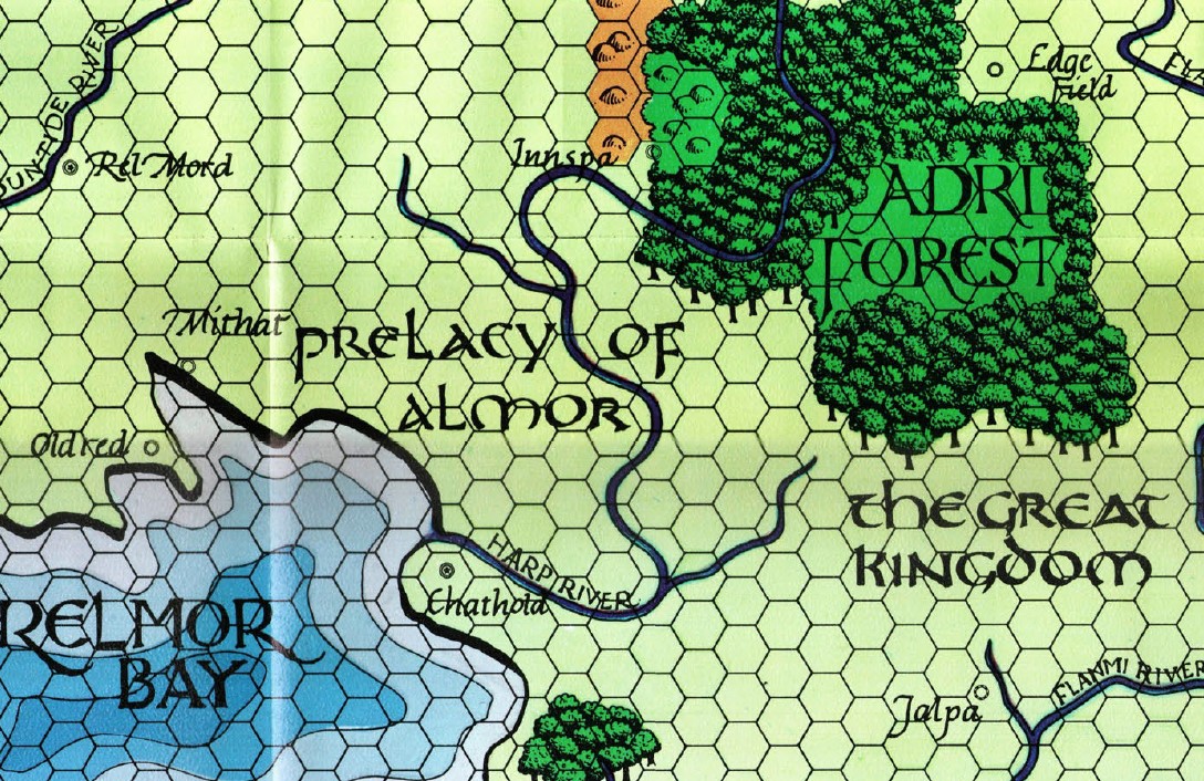
In the 1980 folio and 1983 gold box World of Greyhawk we are told of only two cities in Almor proper. Chathold, the capital, sits near the mouth of the Harp River where it meets Relmor Bay. Innspa, something of a resort town and vacation spot for wealthy merchants and nobles, sits at the base of the Flinty Hills just west of the Adri Forest. Innspa is a well known touristy spot with hot spring-fed bath houses and gnome-built aqueducts6. The entire region looks downright empty. On the map snippet above you also see Mithat, Oldred, and Rel Mord, but those locations are all in Nyrond rather than Almor. Almor itself is a relatively narrow country sandwiched between the Great Kingdom and the Kingdom of Nyrond. Given that, it looks like a small area on this map but remember that these hexes are 30 miles across, so the whole of Almor is roughly 300×360 miles, though of odd shape. That’s 108,000 square miles, or 69,120,000 acres, or 27,971,871.6 hectares – there is a LOT more room in there for cities, towns, castles, and roads.
The Paizo / Dungeon Magazine Map of Greyhawk
The map above was created with just the 1980 World of Greyhawk setting information, and so contains the barest of information on the Prelacy of Almor. Let’s take a look at the Greyhawk map produced by Paizo publishing and released in 4 parts, each in one issue of Dungeon Magazine numbers 118-1217. This map was made during the Living Greyhawk Campaign years and so depicts Almor after the Greyhawk Wars8,9,10, when it was a protectorate (and eventually a Duchy) of Nyrond11,12,13. This map contains more cities and strongholds than what is found on the Darlene Map, but doesn’t show roads and, like the Darlene Map before it, uses 30 miles per hex and doesn’t delineate national borders.
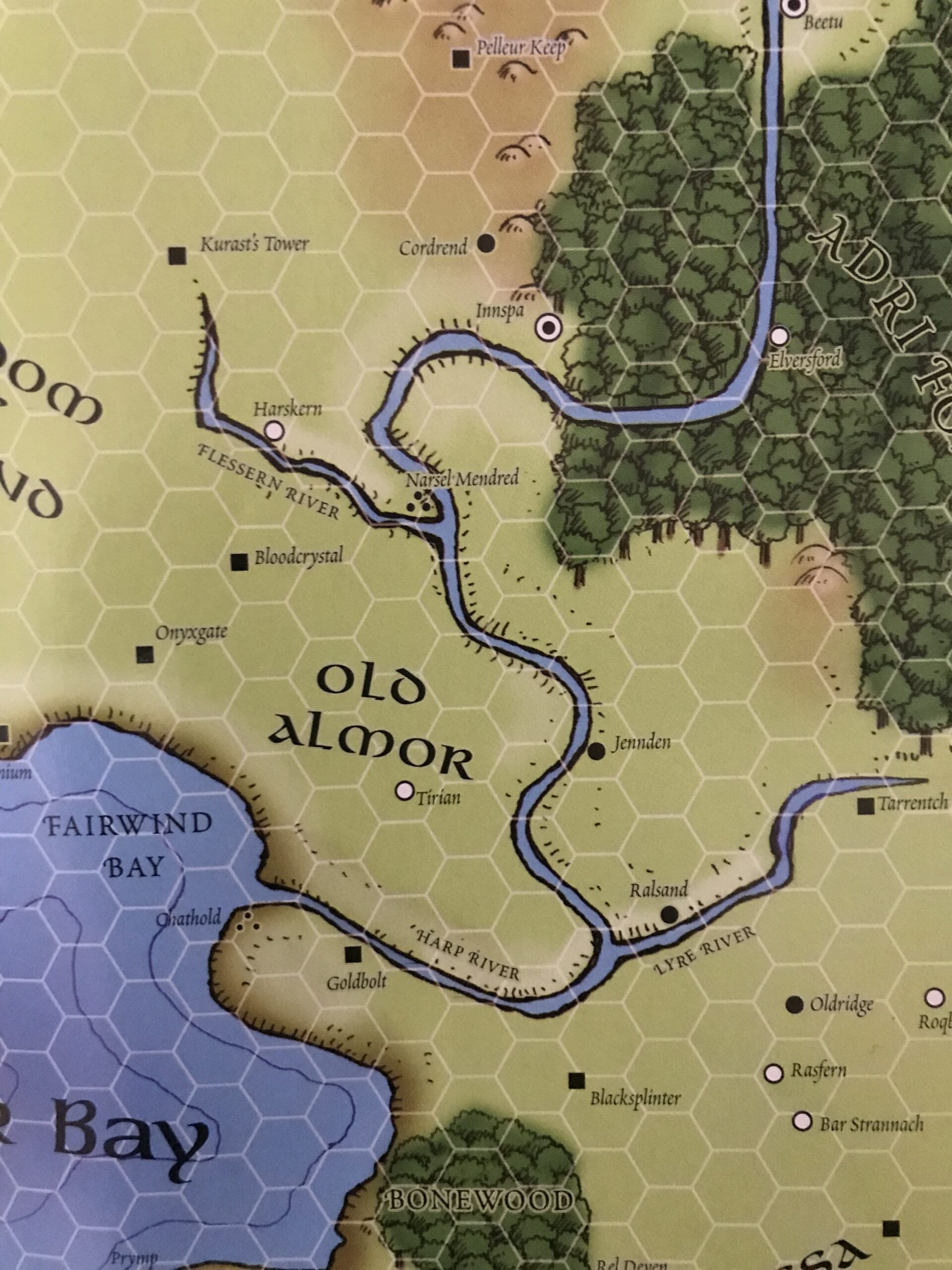
We now see that the bay where the mouth of the Harp River enters the sea is named Fairwind Bay14,15, and we also see Chathold and Innspa, the two towns visible on Darlene’s Map. But now we see many more points of interest included in the area. Onyxgate, Bloodcrystal, Goldbolt16, and Kurast’s Tower17 are fortifications (towers, castles, or fortresses) and there is a fifth Almorian fortification at Millennium18,19, just at the western cutoff of the map as shown. Three small towns, Tirian, Harskern, and Elversford20 are also visible within Almorian lands. Harskern has a hidden tidbit concerning Iuz and Tirian has some protectors in the form of Almorian Irregulars21. Innspa, Narsel Mendred, and Chathold are cities, though by this time Chathold and Narsel Mendred are ruins22. The destruction of these cities is given quite a lot of detail in Ivid the Undying, including a description of the events surrounding the Day of Dust. However, in 576 CY those two cities would be intact and bustling with activity. I will also point out that the Fortress at Bloodcrystal did not exist until Duke Szeffrin, the animus seated as ruler of Almor by Ivid V during the Greyhawk Wars, used some evil magics and pacts to bring it into existence23,24. The small keep above the dungeons at Onyxgate was built by priests at the direction of the Overking25, so while the Onyxgate location existed in 576 CY, it was more an old ruin dungeon and not a working castle location. That is, while the “gate” that gives Onyxgate part of its name was certainly present in 576 CY, it was at least a mile beneath the ground and hidden from the Almorians, including the rulers, nobles, and members of House Cranden, for generations26. As such neither Onyxgate nor Bloodcrystal would be visible on a map of Almor in CY 576.
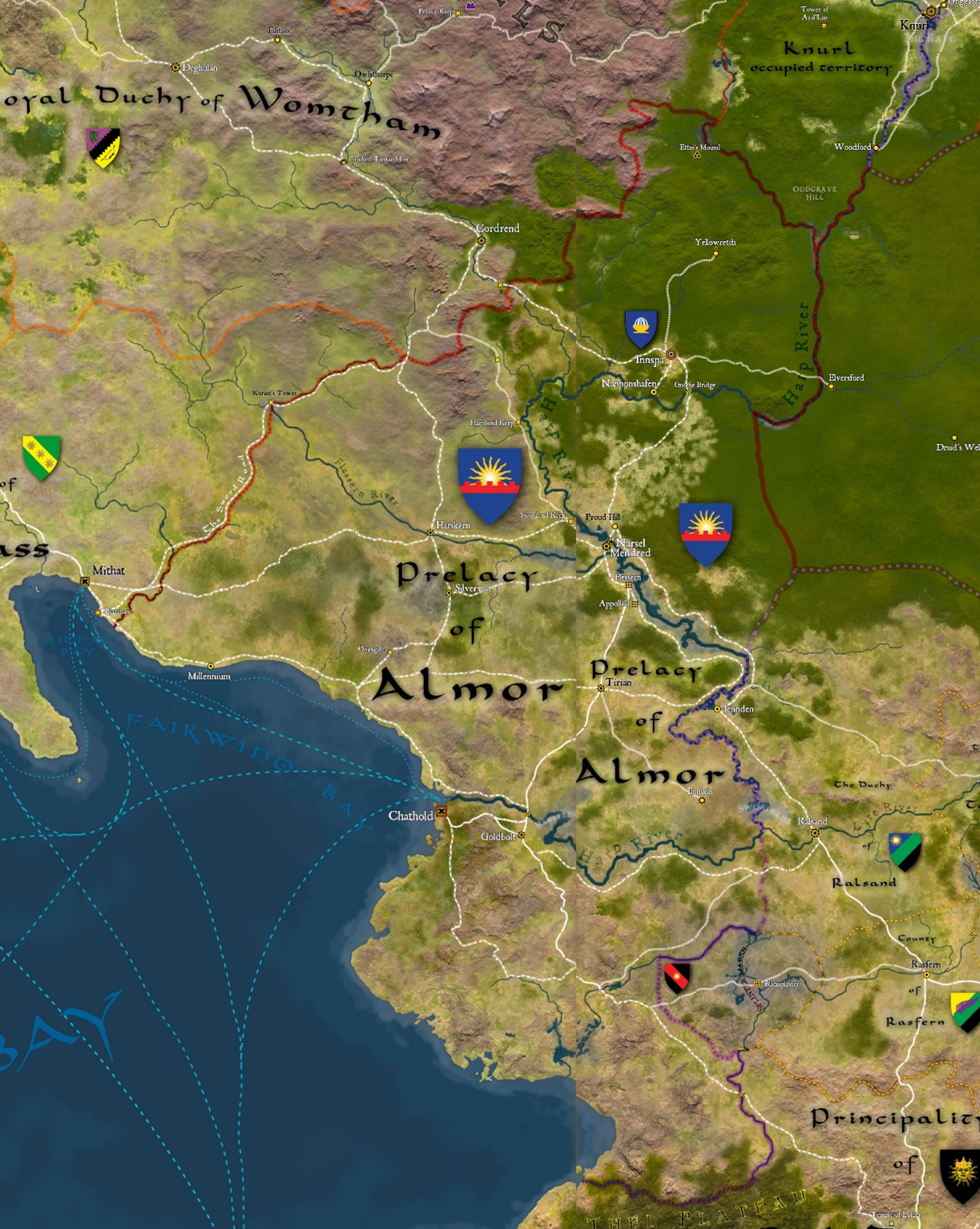
Anna Meyer’s Map of Greyhawk
Let’s turn our attention to the wonderful map created by Anna B. Meyer. She incorporates the 2nd and 3rd edition D&D publications as sources for her cartographic choices, so her rendition of Almor has a lot more detail than the the Darlene map even though it is set in the same campaign year (576 CY). Anna’s map also includes national/political borders, and includes towns/fortifications from as many official sources she can access, including some very rare and hard-to-find adventures from the Living Greyhawk campaign. Even the Paizo map did not do this, making Anna B. Meyer’s map the most comprehensive map of the Prelacy of Almor circa 576 CY available to date.
version of the World of Greyhawk 576 CY
Along with the previously mentioned locations, Anna’s map has several new locations to add to the list! The first thing to notice is that the western border of the Prelacy (red line is national border) has been extended westward to officially include Millennium, placing the border between that fortification and the city of Mithat, a Nyrondese holding. The northwestern border runs up to Kurast’s Tower, which is also in Almorian lands, a fact that was unclear on previous maps, even if the location was marked. Harpbend Keep, Swordend Keep, Castle Von Flessern27, and Castle Appolled28 are all now on the map in Almor proper. Several towns/cities have also been added, including Tomkin, Silverwat, Proud Hill, and Nannonshaven29. Several of these locations are mentioned or detailed in the Nyrond Gazetteer once hosted online on the Wizards of the Coast Living Greyhawk website. Sadly, much of this information is lost to time, but some of it is available if one has the ability to take a deep dive into the internet archive/wayback machine. Some areas that were detailed or visited only in Living Greyhawk adventures are not available to mine for lore.
Moving on with what we do know, two other areas of interest, along with a couple of bridges over the Harp River, have been added to the map inside Almor borders. Ettin’s Mound, not so much a settlement as an historical location, is the site of an ancient battle that is now inhabited by a dangerous band of ettins that pretty much every inhabitant of the area avoids30. Yellowretch is an old gnomish ruby mine that belches out a noxious gas often enough to be dangerous, but magical emanations make it an area that holds interest for adventurers31. Meanwhile, the eastern border has been refined and the placement of Elversford modified slightly, leaving it on the east side of the Harp River, just outside of Almorian lands32. This modified location on Anna’s map is true to the map of the Adri Forest found in Ivid the Undying.
What of the Southern Lands?
If you’ve been looking for all the towns I’ve mentioned on this map, or on the zoom-capable map posted on Anna’s Website (no, seriously, go there, the GH map is fabulously detailed, check it out!), you have probably noticed the striking lack of any villages, towns, or fortifications in Almor south of the Harp River. In fact, the area stretching down the coast of Relmor Bay from Chathold to the Thelwood is devoid of settlements. There MUST be some settlements there – the terrain contains arable land good for agriculture, hills which may be good for limited mining, and a coastline ripe with areas to place fishing villages and docks capable of shipping goods up to the capital. There are enough large roads and rivers to provide caravan access to the southern reaches of Almor. Another reason for having a slew of southern settlements is that the Crandens, the most prestigious and aristocratic noble house in Almor, have good relationships with the nobles of Rel Deven, some of whom are members of House Cranden by blood33. What’s more, the people of the Southern Province, just over the border between the two lands, are not so different from their Almorian neighbors, and there is little to no cause for animosity between the two peoples in 576 CY.
It makes sense that there ARE settlements in the southern lands of the Prelacy, it’s just that they were never named or detailed in any published greyhawk work that I can find. It is entirely possible that at least a few towns have been described in Living Greyhawk adventures, but I have access to only a tiny portion of those, and none of those are in Old Almor or Northern Ahlissa, so I have no way of knowing for sure34. In any case, as a DM running a game in Almor, I see the lack of southern settlements as a feature, not a bug – this is a prime opportunity to develop that area as the DM sees fit! So, that is what I will be doing as I prep my campaign. All of my choices will be based on published work, but of course I will be taking some creative liberties with these as I create maps, adventures, and new lore to fill in the gaps. So that’s what you can expect to see here in this space in the near future.
Endnotes
- Gary Gygax, A Guide to the World of Greyhawk Fantasy Setting (Lake Geneva, WI: TSR Inc., 1983), np. The two-piece fold-out map which was packaged in the 1983 World of Greyhawk boxed set, and also was in the tucked into the 1980 World of Greyhawk Folio, is usually referred to as the Darlene Map and set the standard for RPG setting maps for a very long time.
- Gygax, A Guide to the World of Greyhawk Fantasy Setting, 18.
- Gary Gygax, Glossography for the Guide to the World of Greyhawk Fantasy Setting (Lake Geneva, WI: TSR Inc., 1983), 3.
- Davis Chenault et al, Castles & Crusades Castle Keeper’s Guide 3rd printing (Little Rock, AR: Troll Lords Games, 2021), 115-151, 195-211. Chapter 6 provides lots of excellent information about the size of settlements, populations, and how much land is needed to grow enough food for the city’s population. Chapter 10 provides a nice overview of feudal power structures, ranks of nobility, and land as a reward.
- S. John Ross, Medieval Demographics Made Easy (Cumberland Games and Diversions, 1993), 1-6. This supplement presents a short, easy to digest treatise on the structure, location, and size of medieval settlements. It also gives some historical context with a look at how this would be adjusted for a fantasy setting.
- Carl Sargent, Ivid the Undying (Lake Geneva, WI: TSR Inc., 1995), 77.
- Rob Lazzaretti, Dungeon Magazine issues 118-121, (Redmond, WA: Paizo Inc., 2005), np. These 4 maps were blown into 4 different Dungeon Magazine issues (118-121) in 2005 and are still available in PDF form on Paizo’s webstore.
- David Cook, Greyhawk Wars Adventurer’s Book (Lake Geneva, WI: TSR Inc., 1991), 13-19. This 7 page treatise details the Greyhawk Wars and their effect on the Prelacy, including the destruction of Chathold, and the annexation of Almorian lands.
- Carl Sargent, From the Ashes: Atlas of the Flanaess (Lake Geneva, WI: TSR Inc., 1992), 7, 27. This source also summarizes the situation nicely, though with a slightly shifted focus .
- Gary Holian et al., Living Greyhawk Gazetteer (Renton, WA: Wizards of the Coast LLC., 2000), 23-24. This publication brings the setting into 3rd edition D&D and provides a very nice overview of the entire history of Greyhawk up through the current in-game time of 591 CY.
- Carl Sargent, WGR4: The Marklands (Lake Geneva, WI: TSR Inc., 1993), 85-89. This course provides a wealth of information on the Almorian Borderlands in later years of the war, mostly from the point of view of Nyrond.
- Carl Sargent, Ivid the Undying, 145-150. Elaborates on the state of Almorian lands and control during and after the war.
- Brandon Gillespie et al., “The Duchy of Almor” in The Oerth Journal, volume II issue 22, ed. Rick Miller, (Greyhawk Online, 2007), 3-15. This provides an interesting, though unofficial, treatise on Almor’s current state and develops the area further, relying on previous publications, but bring Almor into the Living Greyhawk Era in an expanded way.
- Carl Sargent, WGR4: The Marklands, 73. Appears to be the first instance of the name Fairwind Bay.
- Gary Holian et al., Living Greyhawk Gazetteer, 148. Also mentions Fairwind Bay as a focused area in the greater Relmor Bay.
- Carl Sargent, Ivid the Undying, 139, 147, 149. Onyxgate, Goldbolt, and Bloodcrystal all get much more detail in Ivid than in any other published product.
- Carl Sargent, WGR4: The Marklands, 87, 93. Kurast’s Tower is detailed here and Kurast himself gets a nice write-up in the NPC section.
- Carl Sargent, WGR4: The Marklands, 88.
- Carl Sargent, Ivid the Undying, 148.
- Carl Sargent, Ivid the Undying, 72. Elversford is detailed here, but is slightly outside Almorian lands.
- Carl Sargent, Ivid the Undying, 148, 150.
- Carl Sargent, Ivid the Undying, 145, 148-149.
- Carl Sargent, WGR4: The Marklands, 88. Bloodcrystal’s creation is said to be supernaturally fast (less than a week to build) and possibly required (or enjoyed the effect of) demonic influence granted by demon lord Pazrael.
- Carl Sargent, Ivid the Undying, 147.
- Carl Sargent, WGR4: The Marklands, 88.
- Carl Sargent, Ivid the Undying, 149. The caverns under the Onyxgate fortification are said to be at least a mile deep, where the ‘gate’ of Onyxgate can supposedly be found.
- The Kingdom of Nyrond (Living Greyhawk Website; 2008), np. Castle Von Flessern is detailed in the Nyrond Gazetteer posted online on the Wizards of the Coast Living Greyhawk website, which is now only available on the internet archive/wayback machine.
- Carl Sargent, Ivid the Undying, 146. Castle Appolled is also a location of interest in two Living Greyhawk adventures, NYR3-M01 and NYR4-M01, and also is mentioned in the Nyrond Living Greyhawk Gazetteer.
- The Kingdom of Nyrond (Living Greyhawk Website; 2008), np. Tomkin and Silverwat are mentioned in the Nyrond Gazetteer. Silverwat is a location of interest in Living Greyhawk adventure NYR3-01. Nannonshaven is a location of interest in Living Greyhawk adventure AHL6-01, but is not in Nyrond proper, so isn’t in the Kingdom of Nyrond Gazetteer. I do not have access to the Ahlissan Gazetteer, but I am guessing that Nannonshaven is detailed, or at least mentioned, in that set of information.
- Carl Sargent, Ivid the Undying, 73.
- Carl Sargent, Ivid the Undying, 175.
- Carl Sargent, Ivid the Undying, 72.
- Carl Sargent, Ivid the Undying, 141-142.
- if anyone has access to those Living Greyhawk adventures and can pass them along, that would be much appreciated!
If you have read this far, thank you so much. I appreciate you!
Until Next Time, I wish you good gaming!
~DMSamuel
Everything in this post is unofficial Fan Content permitted under the Fan Content Policy. Not approved/endorsed by Wizards. Portions of the materials used are property of Wizards of the Coast. ©Wizards of the Coast LLC.